Ai2’s October 22 OlmoEarth v1.3 release lets a mapping project begin with features already computed from satellite observations, instead of first running a large model over the imagery. The release pairs a new model with annual embeddings and a browser-based explorer. For a small team investigating land cover, the immediate opportunity is to reuse that earlier computation while spending its own effort on the question and the labels.
An embedding is a numerical representation of what the model has learned about a location. OlmoEarth v1.3 combines a year’s radar and multispectral observations from Sentinel-1, Sentinel-2 and Landsat into a vector for each 10-meter pixel. The full representation has 128 dimensions; its first 64 dimensions can also serve as a smaller representation. Those numbers describe features, not named categories such as forest or farmland.
That distinction explains the release’s two entry points. Someone looking for similar places can compare embeddings directly. Someone making a crop-type map can train a small classifier on top of them. Both reuse a shared representation, but the second task still needs examples that connect numerical features to the categories the project wants to map.
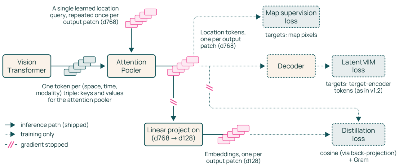
The technical report describes how the model produces that reusable output. A vision transformer processes observations across time and sensor types. An attention pooler combines the resulting tokens into location-specific features, and a projection compresses them to 128 dimensions. The source diagram above separates this shipped inference path from the additional objectives used during training. The smaller 64-dimensional option comes from training the representation so its prefix remains useful, rather than arbitrarily discarding half an unrelated feature vector.
For the reader, the consequence is a choice about where work happens. Precomputed features move the expensive image-processing stage upstream. Fine-tuning remains available when an existing representation does not capture a task well enough, but it no longer has to be the first experiment. This differs from the upstream data creation in SekaiTech’s coverage of synthetic inspection examples: OlmoEarth is packaging features extracted from observations for reuse across mapping questions.
The archive determines which questions fit
The global release is less temporally uniform than the phrase whole planet might suggest. Ai2 says the launch archive covers 2023, 2024 and 2025 globally, while 2017 through 2022 cover selected countries. It describes coverage as land and adjacent coastal waters, with roughly 150 TB of embeddings per year. A project comparing the same location across years therefore needs to establish that both years exist for that location, rather than assume a complete worldwide history.
Annual features also answer a different question from a fresh satellite scene. A map assembled from a year’s observations can support comparisons of land characteristics across years. It cannot, on that basis alone, establish the date of a particular change within the year. The appropriate next evidence may be the underlying imagery or a model run over a narrower time window. Ai2 offers the latter path through OlmoEarth Studio and separately documents computing embeddings on a user’s own infrastructure.
The explorer supplies a practical way to investigate before committing to that work. According to the announcement, it supports similarity searches, classifiers trained from labeled points and GeoTIFF exports without an account or GPU. These are Ai2’s documented capabilities, not results of a SekaiTech hands-on test. A visually coherent map still needs validation against independent examples appropriate to its intended use.
There is a useful audit trail behind the compact features. For each 20-kilometer tile and year, Ai2 says its provenance tables identify the Sentinel-1, Sentinel-2 and Landsat scenes used, with links to their public catalogs. That gives a reviewer somewhere to go when an unexpected patch appears: back to the observations, rather than only to the classifier’s output.
The release uses the OlmoEarth Artifact License, which permits reuse subject to restrictions including military, defense-related and extractive applications. Downloadable weights and data should not be mistaken for unrestricted permission for every use. SekaiTech reviewed the announcement, technical report, model card and license, without running a mapping experiment. For an initial project, the decision is concrete: identify a location and covered year, establish a meaningful labeling task, and use the provenance to investigate where the resulting map disagrees with reality.